Numerical Weather Prediction
DMI carries out research and development on short range numerical weather prediction (NWP) modelling for usage in operational weather forecasting, serving the needs in weather forecasting for the societies in Kingdom of Denmark, including Denmark, Faroe Islands and Greenland. Research and application on NWP is also carried out in externally funded projects and for specialized products.
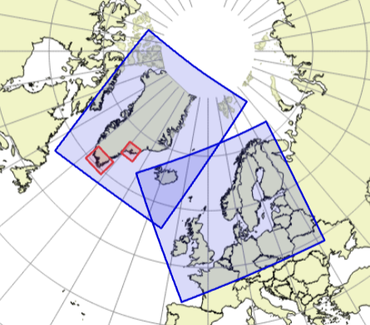
DMI issues a hourly updated 2-day short range probabilistic weather forecast for Denmark, Faroe Islands and an extended area in North and West Europe. The forecasts are based on gridded model products with 2.5 km resolution. In addition, DMI is in the process of developing a rapid update nowcasting system with high resolution. For Greenland, the forecasts are issued with 3h update, also with a grid resolution of 2.5 km. For the southern Greenland coastal regions around Tasiilaq and souther Greenland coast, with particularly challenging and frequent storm occurrence, DMI also issues a 6 hourly updated 2 day forecast with a spatial resolution of 750 m, one of the finest ones in the world.
Operational numerical weather prediction is a great challenge. The main NWP model system used in DMI is Harmonie, which is a non-hydrostatic, mesoscale forecast system jointly developed by the international NWP consortium, HIRLAM (HIgh Resolution Limited Area Model). HIRLAM is a consortium consists of 10 European weather services including DMI. HARMONIE is a model jointly developed by HIRLAM in collaboration with Meteo France and the ALADIN consortium, the latter with national weather services in 15 countries in Europe and North Africa.
For operational HARMONIE system, measurement data on meteorological variables from diverse observation platforms such as surface stations, aircraft measurement, radio sondes, ships, buoys, weather radar and satellites are used in a three-dimensional variational data assimilation. The results of which, together with a corresponding surface analysis, form the initial state for the HARMONIE forecasts.
In order to assess model uncertainties, ensemble prediction systems covering both Denmark and Europe are used.
A separate activity focuses on optimum use of weather radar observations from the DMI’s radar network.
Projects
E-GVAP (EIG EUMEETNET GNSS Water Vapour Programme; Link: E-GVAP )
Project aims: The purpose of E-GVAP is to provide estimates of atmospheric properties based on data from ground-ground GNSS receivers (GPS is one example) in near real-time for usage in operational numerical weather prediction and general weather forecasting. The main property estimated is the zenith tropospherica delay, which contains information about atmospheric humidity. The project is based on a tight collaboration between meteorology and geodesy.
DMI's role: DMI is the coordinator of the programme.
Funding: The programme is funded by the participating national metoffices
The programme is in addition funded implicitly by the geodetic institutions
delivering zenith total delay data at no cost.
Period: April 2005 - December 2018, with third phase running 2013-17, and latest extension (jan.2019 - dec.2023 - E-GVAP 4)
Collaborators: 17 European national metoffices
17 data analysis centers determining ZTD from raw GNSS data (mainly geodetic institutions, but also a few European metoffices and NOAA). A large number of regional GNSS network operators providing raw GNSS data for the analysis centers.
Participants from DMI: Henrik Vedel


